GPX Files
GPX export
Routes, areas, and plans in Karttahimmeli can be exported in GPX format for sharing or archiving.
Exporting a single item
Tail length affects GPX
When exporting a route, GPX includes only coordinates visible with the current tail setting. If you want the full route, first set the tail long enough and make sure the whole route is visible before export.
Open desired map item (route, area, or plan) by clicking it on map. In item details there is download GPX button.
On phone, GPX can be sent directly using WhatsApp, email, or another app.
Exporting multiple items at once
Details are restored automatically on import
A GPX file exported by Karttahimmeli carries each item's note, time, and (for observations) wind readings along with it. Re-importing the same file — into this operation or another one — brings all of that back exactly as it was, not just the coordinates.
Open the observation log, area list, or plan list. Filter or search down to the items you want, then press the Export N observations/areas/plans to GPX button at the bottom of the list. Every item currently shown in the list — minus any hidden with the eye icon — is bundled into a single GPX file, so there's no need to export items one by one.
The downloaded file name follows the app's current interface language.
CSV export
Observations only
CSV export is only available on the observation log's Observations tab. There is no CSV export for teams, areas or plans.
At the bottom of the observation log, next to the GPX button, there is a CSV button (table icon). It bundles the observations currently visible in the list into a single CSV file, suitable for opening in Excel or Google Sheets. A typical use case is attaching the observation log to the operation's final report for officials.
The export follows the same principle as GPX bulk export above: only the rows currently visible in the list are included – filtered or hidden observations are left out. Filter or search for the observations you want before exporting.
Each row contains:
- Team name
- Observation type
- Note
- Timestamp
- Coordinates (WGS84, latitude and longitude)
- The two nearest weather station wind readings, if available
CSV or GPX?
A CSV file is meant to be read and attached to a report in table form – it cannot be imported back into Karttahimmeli. If your goal is to move observations to another operation or archive them in an importable format, use GPX export instead.
An operation owner's GPX bulk-export block (see Operation Manager) also blocks CSV export.
GPX import
GPX files can be imported into Karttahimmeli in two ways. The same import also accepts KML files and IGC flight recorder files (e.g. glider and paraglider flight logs).
In browser
- Select any drawing tool (area, route, or plan — any is fine)
- Press up arrow button
- Select file to import
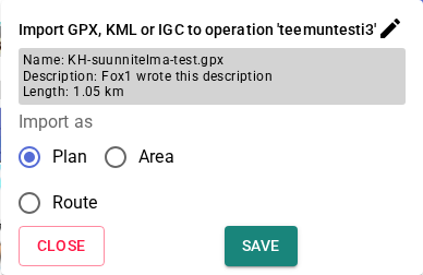
- Select how file is stored (as route, area, or plan)
The map stays visible while you review
The import panel sits at the bottom of the screen instead of covering the map, so you can see where each item is — tap a row to centre the map on it.
Multiple items import in one step
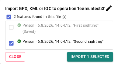
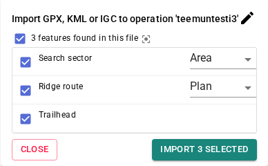
If the file contains several items, they're all listed with their own checkbox instead of the usual one-at-a-time preview. Tick the items you want and press Import N selected to bring them all onto the map at once. Items already present on the map are shown greyed out and can't be selected again.
For files exported by Karttahimmeli itself, each item's type (area, plan, or route), original note, and time are detected automatically — nothing to pick by hand.
For files from other apps or GPS devices, each item's type is guessed from its shape and shown with a small dropdown so it can be corrected before importing.
On desktop, the file can also be imported by dragging and dropping it directly onto the browser window — Karttahimmeli automatically detects a dropped GPX, KML, or IGC file.
On phone
Open the file from your device file manager or receive it from a messaging app. Device asks which app should open file. Choose Karttahimmeli.
Android: default app
If another app has been set as default for GPX files, Karttahimmeli may not appear in choices. Clear defaults in phone settings (Apps → selected app → Default settings → Clear defaults).
Moving items between operations
GPX can also be used to move routes, areas, plans, or observations from one operation to another — a single item, or several at once with bulk export:
- Export the item(s) as GPX
- Switch operation
- Import the GPX into the new operation — Karttahimmeli restores the type, note, and time automatically