Markings
Why mark observations?
Mark boldly
Do not skip marking because you are unsure of significance. Mark it and set importance to Trivial. It stays in system but does not clutter command situational picture.
In field, observations should be marked immediately, not only after return to command post. Reasons:
- Location is known for sure, later exact place is hard to remember
- Timestamp is stored automatically
- "One person's trash is another person's treasure": low-value observation for one search team may be decisive for another
Creating a new marking
Marking is added with plus button, then observation type is selected.
When own location is enabled, marking is automatically placed at GPS location. With gloves, there is no need for precise tapping.
Observation types
Karttahimmeli has six point observation types:
| Marking | Use |
|---|---|
| Air scent (IR) | Dog air scent indication — dog may signal direction toward a scent source |
| Track (jalki) | Dog's indication of a ground track, or a visible footprint found in terrain |
| Item | Any relevant find linked to the missing person — item, equipment or other object |
| Public tip | Tip from the public or possible sighting of the missing person |
| Person | Mainly used in exercises: marks target person location or find site, shows clearly in replay |
| Other | General-purpose annotation for anything that does not fit the above types |
Person marking in exercises
The Person marking shows up as its own animated marker during replay, which illustrates the find that was made. This is also nice, for example, when making social-media videos.
Marking importance
Each marking can be assigned importance:
| Importance | Meaning |
|---|---|
| Very significant | Call command immediately. Affects search direction. |
| Normal | Reportable observation; contact command as needed |
| Trivial | No immediate search impact, but stored |
Trivial markings are shown faded on map and do not clutter situational picture, but they stay stored for later review.
The marking-importance menu also contains special marking types: text mark, grid marking, and the MSO starting point. Any marked point can be converted directly into an MSO planning point (Managing Search Operations) by selecting MSO starting point (IPP) from the importance menu — regardless of its current importance. See Search planning (MSO).
Very significant = call command
If you mark observation as very significant, call command immediately. Karttahimmeli entry alone is not enough. Command has other tasks and may not monitor map in real time.
Direction arrow
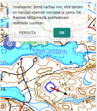
Direction arrow can be added to observation, for example from where sound came or where track continued. Arrow is added while creating observation.
If phone compass works, you can point phone to direction and save automatically. Otherwise direction is set by dragging arrow from crosshair.
Areas and plans
In addition to point observations, areas and route plans can be drawn on the map. Drawing tools are accessed via the plus button. When drawing an area, the app shows the area size in real time; when drawing a route plan, total length and the last segment length are shown.
A drawn area or plan can be given a name visible on the map and free-form comments by tapping the object. Plan colour can be chosen from four options.
Route area — a dedicated tool for drawing search areas for route patrols: draw the route and define the search depth on each side.
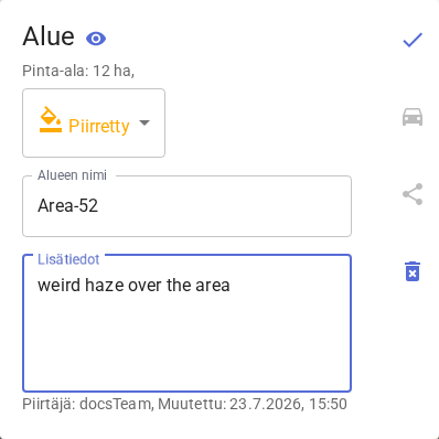
Accessing area details
Additional information for an area is accessible only when the map is zoomed out enough that the whole area is visible on screen. At closer zoom levels, tapping targets point observations or plans instead.
When markings overlap on the map, Karttahimmeli shows a selection window where you can choose the desired item using arrows or by swiping on your phone.
Operating without a network connection
Karttahimmeli also works on a spotty phone network, but a few things are worth noting:
- You can only join a new operation while online
- Map tiles should be browsed into the device's cache while you still have good connectivity — even before setting out to the search location!
- Phone carrier coverage in the field varies. If one carrier works better, you can share that connection over WiFi to the other team members. This actually saves battery for the team, since only one radio has to handle the connection to the phone network.
Offline use
Markings are stored locally and sent automatically when connection returns. Other people's markings are also loaded as soon as possible. Do not close app in forest only because network is down. If the text in the bottom-left corner says anything other than "CONNECTED", the network connection is down. Zooming all the way out and then back in forces the map engine to retry loading. It is also worth moving to higher terrain and loading the needed map tiles there.
Marking is first saved locally and sent to server as soon as network is available. Spinning icon on the add button means upload is in progress.
Reviewing markings
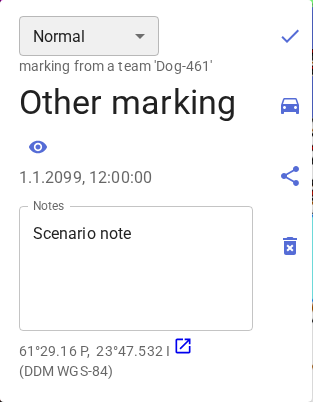
By tapping a marking you can view:
- Timestamp
- Search team name
- Extra info and comments
- GPS accuracy at marking time (with 95% accuracy the team was within the stated radius; multiply by three for 99% probability)
- Wind data from nearest weather stations
Wind data is stored automatically. This is especially useful for dog teams post-analysis.