Search Planning (MSO)
Planning point
Any point marked in Karttahimmeli can be converted directly into an MSO planning point (Managing Search Operations) by selecting MSO starting point (IPP) from the importance menu — regardless of its current importance.
Typical MSO points:
- Missing person's point last seen or last confirmed observation point
- Found item that indicates movement of the missing person
Planning points can also be used in parallel. For example, if missing car is found farther away, two parallel scenarios can be created.
Activating an MSO profile
Open an observation point by clicking a marker on the map. In the observation popup, find the importance selector and choose MSO / IPP. A profile selector will appear — pick the MSO profile that fits the situation.
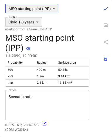
Karttahimmeli immediately draws the profile's distance circles on the map and shows a table with the probability, radius, and area for each circle.
Search probability rings
How to interpret profiles
Profiles are based on statistics from earlier search operations. They show how far from the point last seen people with a similar profile have been found, by percentage.
Example: 50% means half of similar cases were found within 400 meters.
A profile can be selected for planning point, for example Autistic child, Dementia, Young adult, or similar. The profile draws probability rings on map to show where the missing person is most likely to be.
Profiles provide a directional search area, not an absolute answer. In real operations, conditions, local knowledge, and new observations can shift focus.
Hasty Search: 300-Meter Circle
28 hectares is the area of a 300 meter radius circle. The hasty search of the immediate area around the IPP should not be underestimated:
- Area can keep three dog teams occupied for hours
- Most findings in all profiles happen at short distance
- Hasty search should be done first before expanding
Hasty search is critical
A common mistake is to expand immediately because people think the immediate area is "already checked". 28 hectares is large. Thorough coverage needs several search teams and several hours.
Sectoring
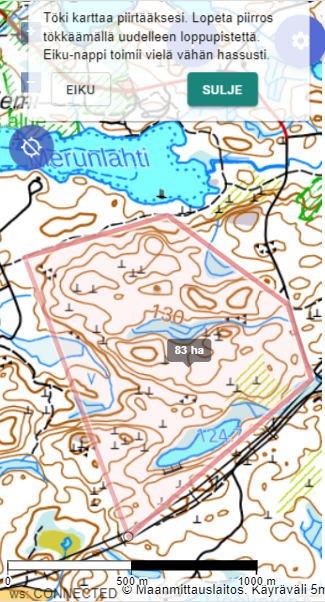
The hasty search area should be split into sectors and each search team gets its own sector. This gives:
- Area can be covered in 30-45 minutes with multiple search teams
- Command gets time to organize during sectoring
- Results accumulate clearly on map
In SAR terminology each sector is a segment — the unit assigned to one resource, for which a probability of detection (POD) can be calculated from coverage and sweep width. Summing POD values across segments gives the overall probability of success (POS) for the search area.
Sector naming follows same rules as other areas. See naming conventions.
Shifting focus
If new information appears during search (item, observation, or tip call), focus shift may be considered. Before shifting:
- Evaluate how reliable new info is (fact or suspicion)
- Do not discard existing plan based on first tip
- Consider opening parallel scenario with separate MSO point
Confirmation bias in search
Humans naturally seek data that confirms existing assumptions. Karttahimmeli helps keep location data factual. Do not interpret map as "target is probably there". Keep open view on data.
Expanding area size
When search radius is doubled, area quadruples:
| Radius | Area | Required resources (relative) |
|---|---|---|
| 300 m | ~28 ha | 1x |
| 600 m | ~113 ha | 4x |
| 1200 m | ~450 ha | 16x |
For this reason: hasty search first. At the start, resources should be focused on the most probable area.
MSO info in area names
Search method does not need to be in the area name. Put it in extra info instead. Method in name makes names long and harder to search.